Architecture
This page shows how Parquetry is built, in seven C4 diagrams, from the systems around it down to the classes of a read. It is for developers who read or change the code. The diagrams name real modules and types: open a type in the source to see the details. Select a diagram to open it at full size.
The diagrams are generated from a Structurizr model kept in the repository, under docs/structurizr/. In the diagrams, brown boxes are parts of Parquetry, grey boxes are other systems, and lighter brown boxes with a dashed border are experimental modules.
System context
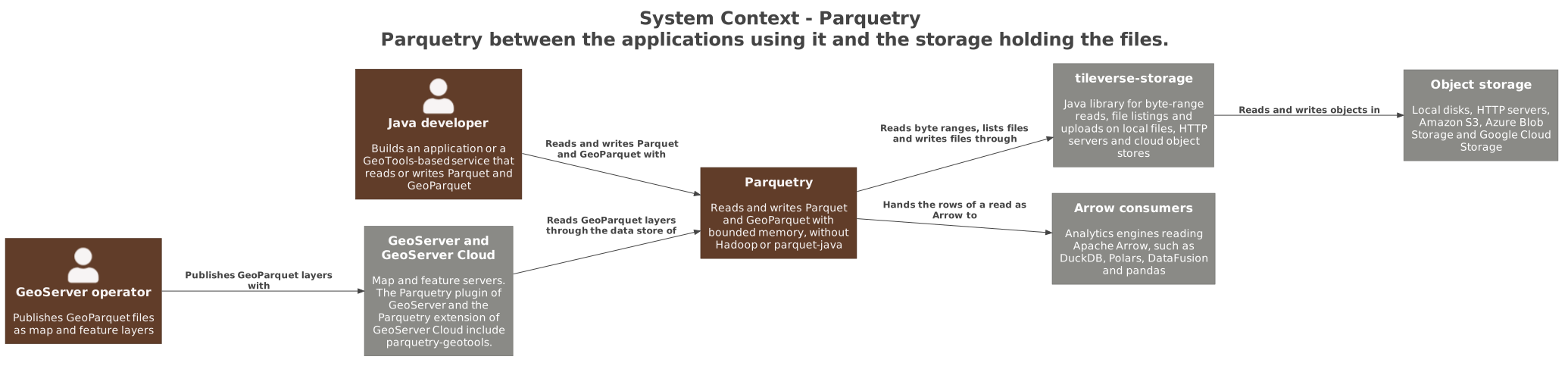
Parquetry is a set of Java libraries, used by Java applications and by GeoServer. GeoServer and GeoServer Cloud reach Parquetry through its GeoTools data store. Parquetry does not talk to object storage itself: it reads byte ranges, lists files and writes files through tileverse-storage. A read can also be handed as Apache Arrow to an analytics engine.
Containers
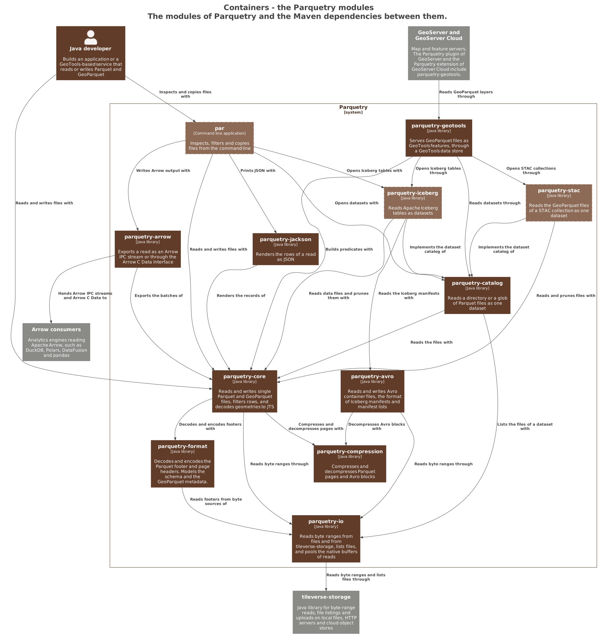
The containers are the Maven modules of Parquetry, and the arrows are the dependencies declared in their POMs. parquetry-core reads and writes single files, over three foundation modules: parquetry-io, parquetry-format and parquetry-compression. parquetry-catalog reads many files as one dataset, and the integration modules build on it. parquetry-io holds the adapter to tileverse-storage. parquetry-core, the Iceberg, STAC and GeoTools modules and par also use tileverse-storage types directly, and the diagram leaves those arrows out to stay readable. Modules lists the modules with their status.
Components of parquetry-core
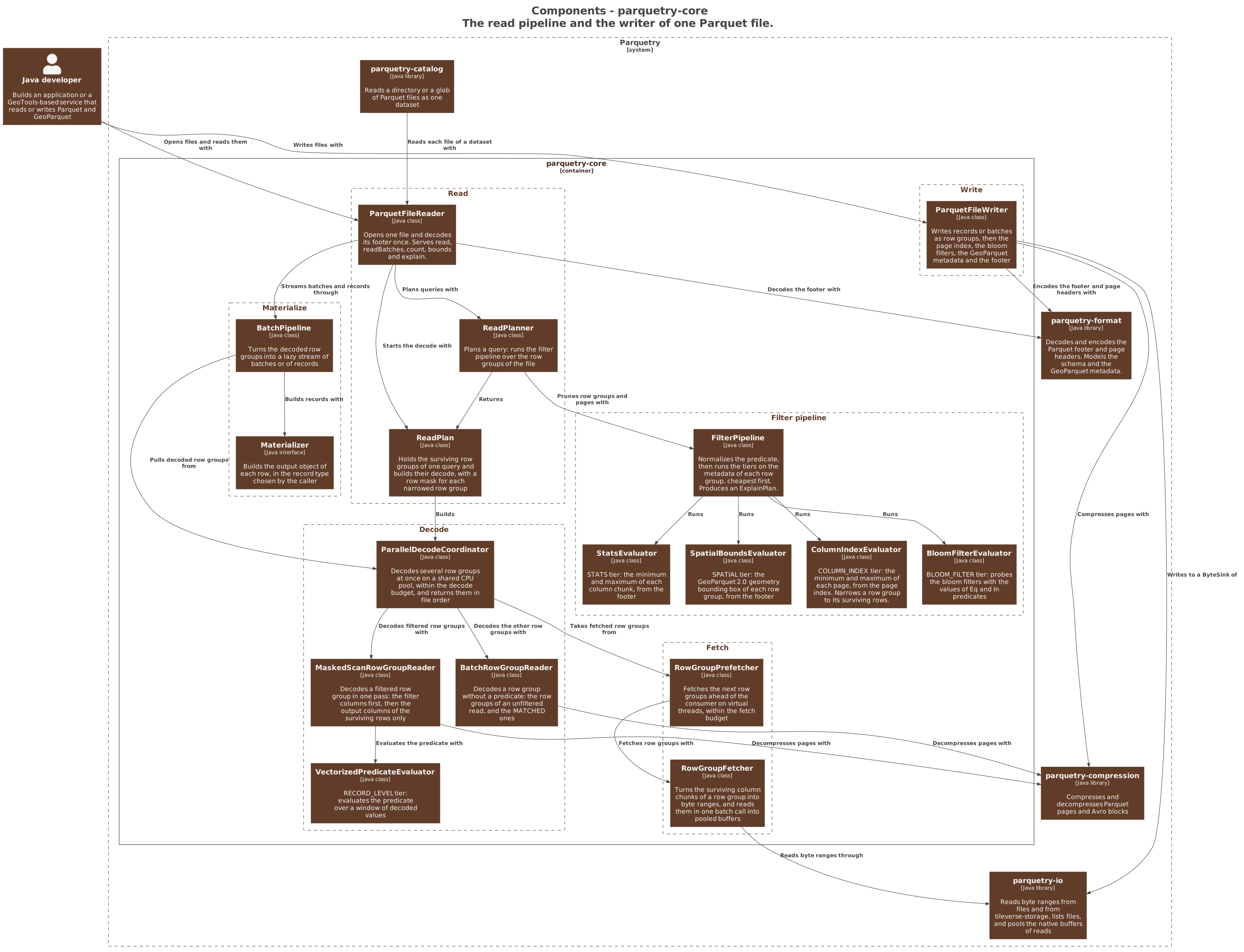
The diagram shows the read pipeline and the writer of one file. ParquetFileReader opens a file and decodes its footer once. ReadPlanner runs the filter pipeline of a query on the metadata of the file. FilterPipeline runs one class per tier: STATS, SPATIAL, COLUMN_INDEX and BLOOM_FILTER. The fifth tier, RECORD_LEVEL, runs later, during the decode, in VectorizedPredicateEvaluator. The fetch classes read the byte ranges of the surviving row groups through parquetry-io. The decode classes turn their pages into batches. BatchPipeline hands the batches, or records built by a Materializer, to the caller. ParquetFileWriter writes row groups, the page index, the bloom filters and the footer. The read path explains the same classes step by step.
Components of parquetry-catalog
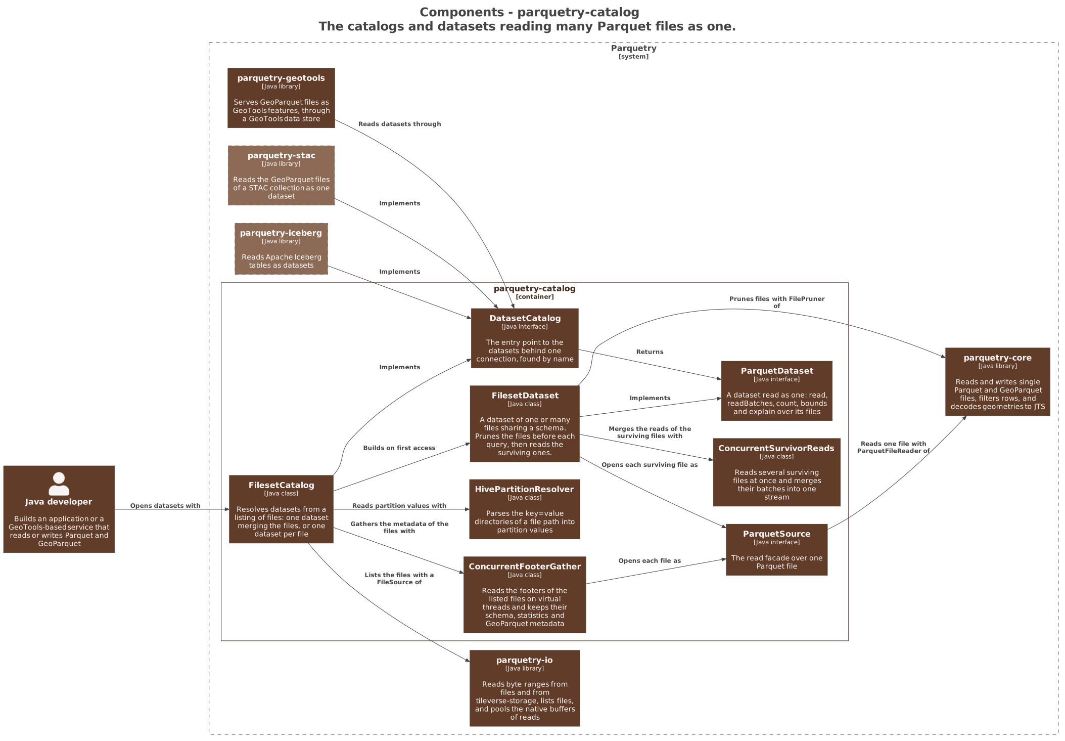
A DatasetCatalog gives access to datasets by name. FilesetCatalog is the catalog over a listing of files: it builds one dataset merging the files, or one dataset per file. It reads the footers of the files on virtual threads, and parses Hive partition directories such as year=2024/. A FilesetDataset prunes its files before a query, then reads the surviving files several at a time. It reads a file through a ParquetSource, over the reader of parquetry-core. The Iceberg and STAC modules provide their own catalogs and datasets behind the same two interfaces. Multi-file datasets shows how to use them.
Components of parquetry-geotools
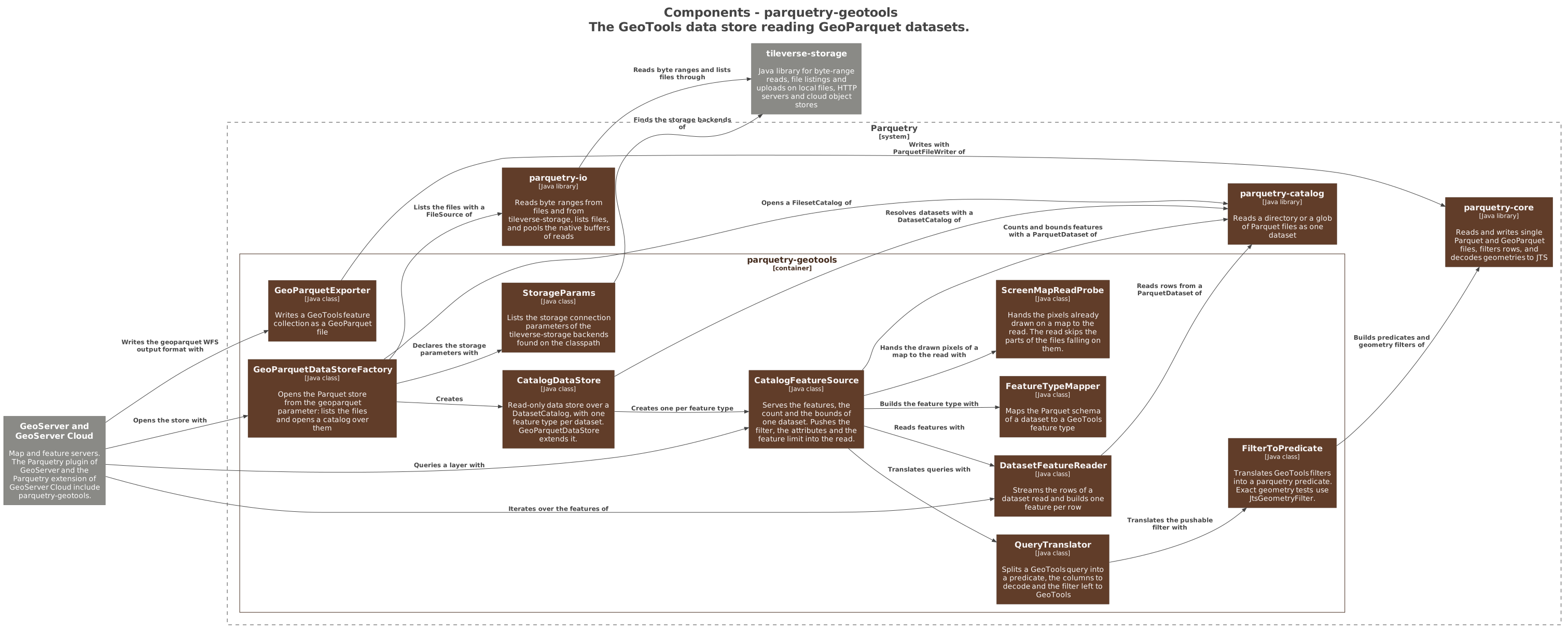
GeoServer opens the store through GeoParquetDataStoreFactory. The factory lists the files and opens a FilesetCatalog over them. CatalogDataStore publishes one feature type per dataset, and CatalogFeatureSource serves the features, the count and the bounds of one of them. QueryTranslator and FilterToPredicate turn a GeoTools query into a predicate, the columns to decode, and the filter left to GeoTools. DatasetFeatureReader builds the features from the rows of the read. ScreenMapReadProbe passes the pixels already drawn on a map to the read. GeoParquetExporter writes features as a GeoParquet file. The GeoTools data store describes the store from the user side.
A filtered read
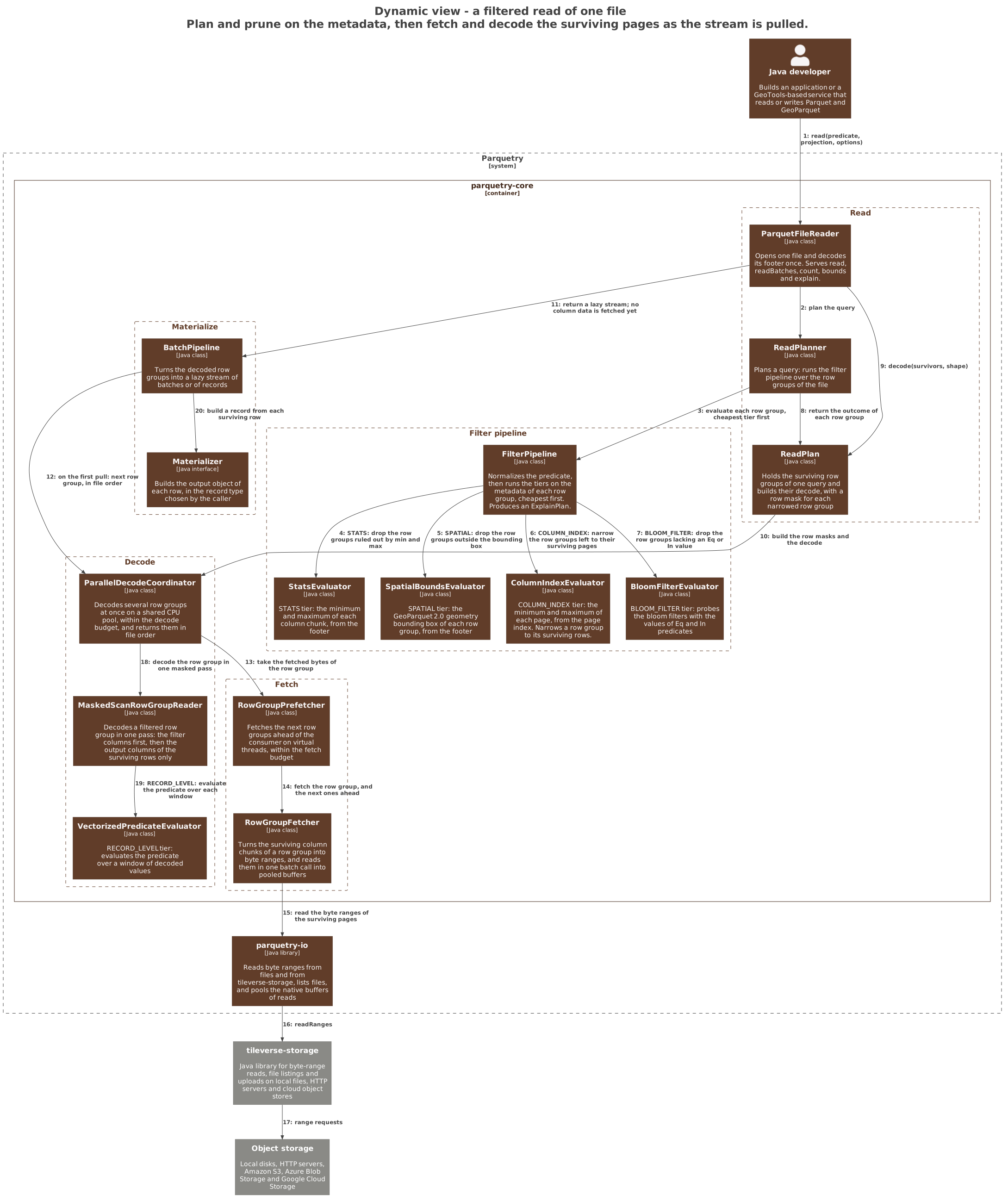
The numbers give the order of the calls in one filtered read of a file. Steps 1 to 11 run inside the read call: the filter pipeline prunes the row groups and pages on the metadata, and the read returns a lazy stream. Steps 12 to 20 run when the caller pulls the first rows. The decode asks for the bytes of a row group, the fetch reads the byte ranges of its surviving pages from storage, and the masked scan evaluates the predicate while it decodes. The read path follows the same steps in more detail.
A GeoServer request
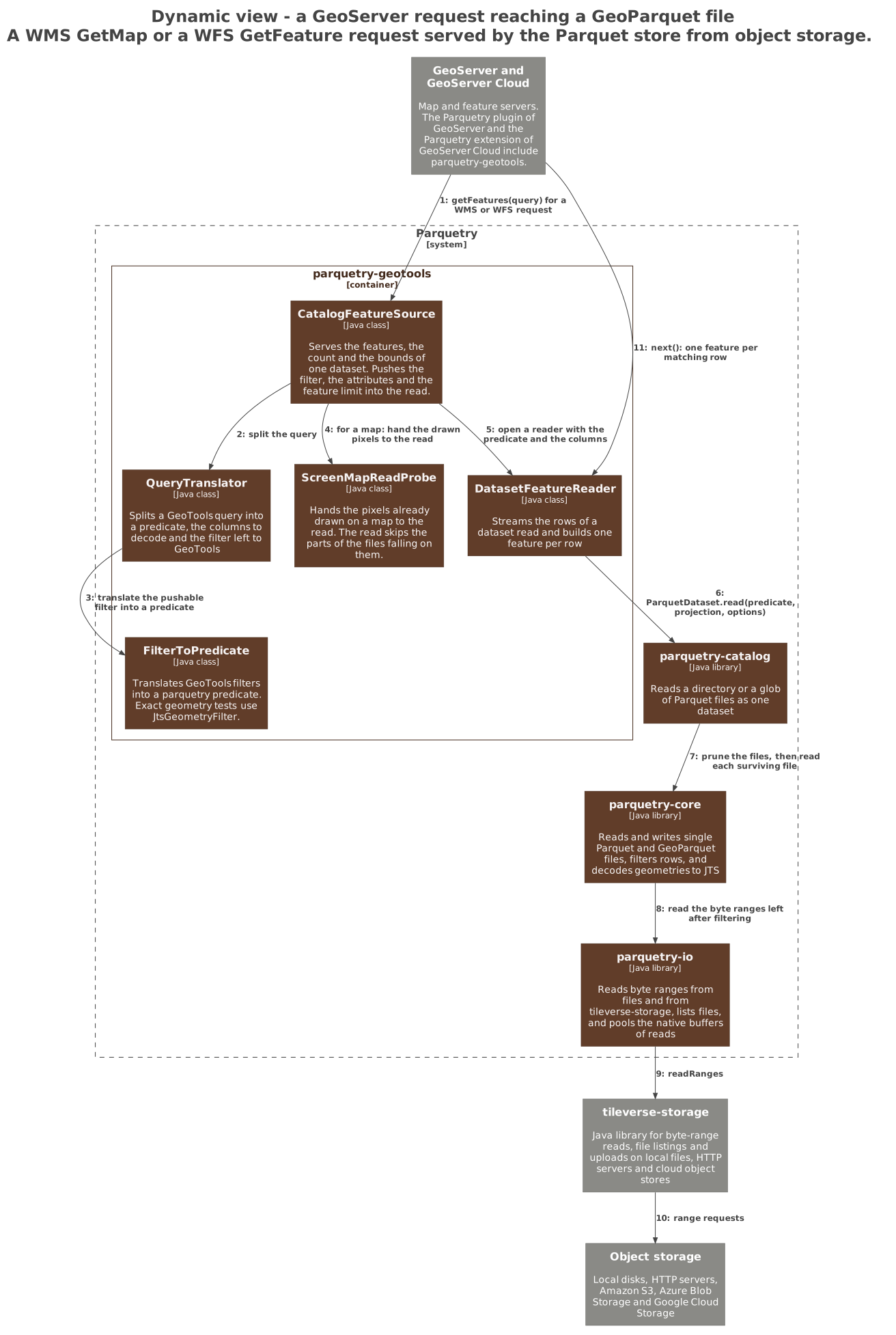
A WMS GetMap or a WFS GetFeature request asks the store for the features of a layer. The feature source translates the filter of the request into a predicate, and opens a reader with it. For a map, it also passes the drawn pixels to the read. The dataset of parquetry-catalog prunes its files and reads the surviving ones with parquetry-core. The reads fetch only the byte ranges left after filtering, through tileverse-storage. GeoServer then iterates over the features, one per matching row.